Introduction
The Celtic and Gaelic Department of Glasgow University is currently undertaking a major research project (Iona Namescape), looking at the place names of Iona and its environs. The research team is keen that local people should be involved in this, and so they have set up a Knowledge Exchange Liaison Group (KELG) as a meeting point for the sharing of information. Obviously, the Ross of Mull is a big part – the main one even – of the 'environs' of Iona, and the team invited the Ross of Mull Historical Centre (RoMHC) to be part of this exchange process. Several Ross of Mull people are members of the group.
Iona is of course hugely famous and much documented, and it is, in any case, the primary focus of the research project. In this situation, it would be easy for the Ross of Mull to be overshadowed. After the first meeting of the exchange group, local representatives agreed that the Mull voice should be heard, and so have been carrying out some investigations into place names on this side of the Sound of Iona. Maps have been an important feature of this research.
Maps
The systematic mapping of the Highlands of Scotland developed dramatically in the eighteenth century. This was prompted to a large degree by the Jacobite rebellions – the British Government realised that, if it was to impose control on the unruly north, it would have to have a better understanding of the region's terrain. So it was that, from the first decades of the century, military engineers were sent to the Highlands to record the topography and also to design fortifications. Then in 1747, a year after the Battle of Culloden and the ultimate defeat of the Jacobite forces, the Military Survey of Scotland was launched. This huge undertaking ran until 1755 and it was overseen by an engineer called William Roy. Roy and his teams of surveyors produced an almost complete map of the whole of Scotland. Roy's map was a landmark, not least in terms of delineating the mountains and glens of the Highlands, and it laid the foundations for the Ordnance Survey maps of the nineteenth century – despite the fact that it didn't include any of the islands. It wasn't until quite late in the nineteenth century, that the whole of the Highlands and Islands (the Gàidhealtachd, to give it its Gaelic name) was mapped in complete detail.
For anyone undertaking a study of place names, Ordnance Survey maps are a tremendously important resource. Not only do they record the names of centres and settlements, but also of countless natural features – hills, streams, bays, headlands, islands, rocks, caves and skerries, woods, fields and more. In order to find these names, Ordnance Survey staff asked local people. We can only imagine how difficult that must have been in a place such as the Ross of Mull – few, if any, of the mapmakers would have spoken Gaelic, and yet almost all of the local place names were of Gaelic (and/or Norse) origin, and Gaelic would have been the first language of most of the people they encountered. Partly for that reason, they tended to consult those who had had a formal education – landowners, doctors and schoolmasters, for example. One positive outcome of this was that the names we have today are generally quite accurate in terms of spelling and grammar – both of which are notoriously complicated in Gaelic.
For all the excellence of the Ordnance Survey maps, they had limitations. The nineteenth century was turbulent time for the Gàidhealtachd – the middle decades of the century in particular were marked by economic hardship, food shortages, clearances as they're now called (when landlords forcibly evicted people from the land) and depopulation. In the Ross of Mull (as elsewhere) whole townships were deserted as people left the island in search of a better way of life, or were driven away. These people took with them their language and culture, and their intimate knowledge of the land their families had worked for generations. Countless place names, both major and minor, would have been lost in the process, never to be recovered.
There was another, more minor problem. As the mapmakers discovered, local people didn't always agree about place names. Sometimes they would offer several different names, or perhaps several variations of the same name, for one place. In these instances, Ordnance Survey policy was to record them all, and then decide which of their informants seemed to carry the most authority. We can guess that the word of so-called 'ordinary' people would be the least likely to be used.
In any case, a certain difficulty arises from printed maps. In recording place names as they were at a particular point in time, maps convert something that is in reality constantly changing – place names change as our relationship with the land changes – into a kind of fixed and static end-point. On the one hand, this is useful because it's visible evidence of the past. The origin of the name (Gaelic, Norse or, more recently, English) helps to locate it in time. The name itself has a 'meaning', which can't always be figured out, but often can – in the case of Gaelic place names in particular, the meaning nearly always relates to natural features (tòrr – a hill, eilean – an island, leac – a slab of rock, gleann – a glen, and so on). From that information, we can work out something of the past connection between people and land. However, we gain no sense of an evolving or continuing relationship with the landscape, and that's one of the reasons why it's so important that we hear the voices of people.
Voices
(Sources include local people, some still living, who have generously given information to interviewers, and also recordings conducted by RoMHC and Tobar an Dualchais https://www.tobarandualchais.co.uk/ )
At the most obvious level, place names are simply a way of identifying places so that we can refer to them conveniently. As soon as we listen to local 'voices', however, we realise how closely people lived with the land in days gone by. Place names for them are about far more than origins, dates and linguistic 'meaning' (the questions beloved of academics) – local people don't dwell very much on these at all. Instead, place names trigger memories, and represent associations and connections. And so, we hear stories, about a way of life – of people gathering sheep, cutting peat, harvesting crops and thatching houses. There are stories of dramatic events – a sheep being rescued from a dangerous cliff; a fishing expedition which had to be abandoned because the weather changed; a search party going out to look for a man who had failed to come home, and finding him dead on the moor; a congregation worshipping at low tide or in a cave because the landlord wouldn't let them use their meeting-house.
Characters emerge: the Jacobite fugitive, Allan Cameron, who is said to have hidden in an underground cave and been supplied with food by local people; the sheep-stealer, Donnchadh Mòr, who was of such unusual strength, he could throw the carcasses of two sheep over his shoulder without difficulty; Mary Walls who lived at Toba Bhreac, and who would walk miles across the moor to fetch water from a distant spring, because it was cleaner than the water in the nearby burn (this was for drinking and cooking, but also for laundry because she was a house-proud woman). Sometimes, the stories are so dramatic, we can hardly believe them. Many will have heard the tale of the eighteenth century ship, bound for America, and pursued by a huge whale as it came near the western islands. The sailors tried to drive the whale away by throwing things at it, first of all a three-legged stool, which the creature promptly swallowed, then a box of apples, which it also ate, and then, in the hopes of satisfying its appetite, an old woman who was on board. The next day, a whale was washed up on the shores of the Ross of Mull, and when the local people went to cut it up, what did they find in its belly but the old woman, sitting on a stool, eating apples!
Throughout these stories, it is clear that place names were liable to change. Many of those used do correspond to the names on maps, but many don't. The headland on the north west side of Kintra, for example, was recorded by the Ordnance Survey as Sròn an t-seann bhaile (the nose-shaped headland of the old township), but by the twentieth century, it was known locally as Rubha Dubh (dark headland). What the map makers noted as Port Aonarach, was – and still is – called Port Nois. There were local names which never featured on maps, and it's striking how many of these contained personal names. From Tom Aitchieson's map of Kintra, we have Tòrr Mòr Iain Dòmhnaill (the big hill of Iain, son of Donald); Dàil Iseabail (Isobel's field, named after one of two sisters who ran a shop near Kintra); Cnoc Annaig (Annie's hill, again named after a local woman); and Maol Iain Mòir nan Trosg (the rounded hill of Big Iain of the Cod, a man who was famous for drying fish there!)
Sometimes the area covered by a name has changed, as in Conarst on the south coast which seems at one time to have referred to a much bigger expanse of ground than it does now. The name Creich, on the other hand, referred to a smaller area than it does today. When the Ordnance Survey maps were created, there was almost no evidence of English-language names – one of the few was Livingston's Rocks – but inevitably, these have become more common as Gaelic has declined. Names like Campbell's Croft and the Cottar's Cottage seem to have been coined directly in English, even though the families who used them did speak Gaelic. At some point, Fionnphort became Finnafort, Poit Idhe became Pottee, and Ceann Tràgha became Kintra. An Caolas (Sound of Erraid) is often given in its English form, The Narrows. And of course, today we all use a mix of Gaelic and English all the time without thinking about it, in names like The Beinn (given on the map as Beinn Chladain), The Dalaharra Gate (the middle bit from Dàil a' Charraigh) and The Pottie Road End – quite an important place nowadays, but not given, as a name at least, on any map.
Local voices, past and present, transform the two-dimensional map, fixed in time, into a living, changing artefact. Given their importance, it would be fitting to let a local, Gaelic-speaking (and long gone) voice have the last word. Click on the link https://www.tobarandualchais.co.uk/track/17791?l=en to hear Donald MacFarlane who lived at Deargphort in retirement, and was known locally as Dan Dubh. He was a great story-teller. In the clip, he talks of a man called Alasdair MacLùcais, who lived in Fionnphort, and who would go at night with his sister to the hill called Sìthean Riabhach beyond Ardfenaig Moss. The pair would enter the hill and dance all night with the fairies – but they would be careful to take a cockerel with them, and as soon as it crowed in the morning, they would know to leave the hill, lest they got trapped there for ever. In the recording, Dan says, 'Tha mi cho eòlach air an àite sin 's a tha mi air far a bheil me an ceartair'/'I'm as familiar with that place as I am with where I am just now'. Then, just before the recording is cut off, the beginnings of a chuckle can be heard, encapsulating something of Dan's great character.
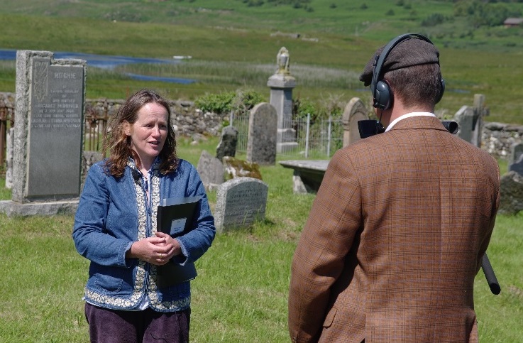
Dr Eleanor MacDougall PhD
Photo below of Eleanor being interviewed by Andreas Wolff for a BBC Alba programme called An Là.
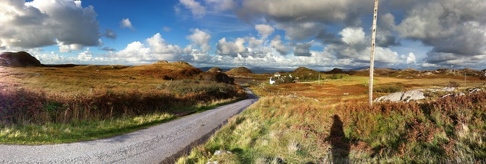
The Ross of Mull is an extraordinary microcosm of all that draws visitors to the Hebridean Islands. The scenery, as you travel along the single-track road from the ferry at Craignure is breath-taking. You experience in the many walks in the area a true sense of wilderness; the secret bays with their beaches of silvery sand, the abundance of wildlife and the innumerable marks on the landscape of the lives of past generations and communities long gone. The Ross of Mull is a compelling place for anyone fascinated by history and the ancient way of life of the Gaelic people.
By Phone: 01681 700659 By Email: enquiries@romhc.org.uk
Our museum is open Monday - Friday, 10am - 4pm